
San Juan Islands, Washington, USA
The image captures the interior of a ferry heading toward Friday Harbor in the San Juan Islands, a scenic archipelago in the Pacific Northwest known for its temperate climate, forested islands, and abundant marine wildlife (including orcas). The photo, rendered in black and white, emphasizes the ferry's utilitarian design, with long rows of identical cushioned seats and tables facing large rectangular windows. The lighting—a repeating pattern of bright overhead fluorescent fixtures—creates a rigid, grid-like composition on the ceiling, starkly contrasting the soft, blurred forms of passengers looking out at the passing landscape, capturing a moment of quiet, communal journey across the waters of the Puget Sound region.

Mono Lake, California, USA
Mono Lake is a striking natural wonder in the California high desert, famous for its saline and alkaline waters and the dramatic Tufa Towers exposed by past water diversion. While the lake sustains an efficient food web of brine shrimp for millions of migratory birds, the surrounding arid landscape is dominated by hardy Big Sagebrush and Pinyon Pine. Only in the freshwater riparian zones are groves of Quaking Aspen and vibrant wildflowers found, illustrating the sharp contrast between the lake's harsh, mineral-rich basin and its life-sustaining water sources.

Sebastopol, California, USA
The Gravenstein apple is profoundly important to the history and identity of Sebastopol, California, defining the area's agricultural heritage for over a century. From the late 19th century into the mid-20th century, the Gravenstein was the dominant cash crop in Sonoma County, earning Sebastopol the title of the "Gravenstein Capital of the World." Its early harvest made it ideal for shipping, and the local economy thrived on the fruit, supporting numerous canneries, processing plants, and dehydrators in and around town. Although the number of orchards has dramatically declined due to urbanization and market pressures, the Gravenstein remains a treasured local symbol, celebrated annually during the Gravenstein Apple Fair, preserving a vital piece of the region's agricultural past and community pride.

Zagreb, Croatia
Zagreb's history began in the Middle Ages as two rival settlements—the fortified burgh of Gradec and the ecclesiastical Kaptol—which eventually unified to form the modern city and the capital of Croatia. Its downtown shopping area, centered on Ilica Street and Ban Jelačić Square, reflects this heritage, blending grand Austro-Hungarian architecture with modern commerce. This vibrant, walkable hub offers a mix of international retail chains, local Croatian designer boutiques, and traditional shops. Zagreb's proximity to key regional routes, including historical trade paths connecting Central Europe to the Adriatic Sea, and its strategic location near navigable rivers like the Sava (a tributary of the Danube), helped it become an important trading nexus for goods traveling in the wider Danube region during the early medieval period.

Sebastopol, California, USA
The 1936 Ford Orchard Truck was a specialized version of the standard Ford half-ton pickup, designed specifically for agricultural use. Its defining feature was a low-profile design—often a flat-bed or low-slung stake bed—engineered to pass underneath the low-hanging branches of fruit trees without causing damage during harvest. Like the standard '36 Ford, it featured an all-steel cab and was powered by the reliable, 85 horsepower 221 cubic inch Flathead V-8 engine, making it a durable and efficient tool highly valued by farmers. Rather than being operational, some of these classic Ford workhorses can now be found sitting deep within the older orchards and vineyards of places like Sonoma County, weathered and static, a picturesque relic of time; these rusted artifacts stand as tangible monuments to the industrious past and the history of California's agricultural boom.
Near Plitvice Lake National Park, Croatia
The profound demographic reversal in the region surrounding Plitvice Lakes National Park, brought about by the Croatian War of Independence (1991–1995), left behind a physical landscape of widespread abandonment and destruction. While the war involved an initial displacement of Croat residents, the most impactful population shift was the definitive, mass exodus of approximately 200,000 ethnic Serbs from the broader Krajina region during and after the 1995 Croatian offensive, Operation Storm.1 This displacement, which fundamentally transformed the region's demography, resulted in an enduring visual legacy of war-time devastation. The fleeing population left behind vast numbers of private homes, agricultural buildings, and villages that were subsequently looted, vandalized, or deliberately destroyed. This dramatic shift created a landscape marked by thousands of abandoned structures, often characterized by shell damage, collapsed roofs, and bullet-pocked walls, standing as silent and powerful evidence of the conflict and the ensuing humanitarian crisis that prevented the return of many displaced residents.

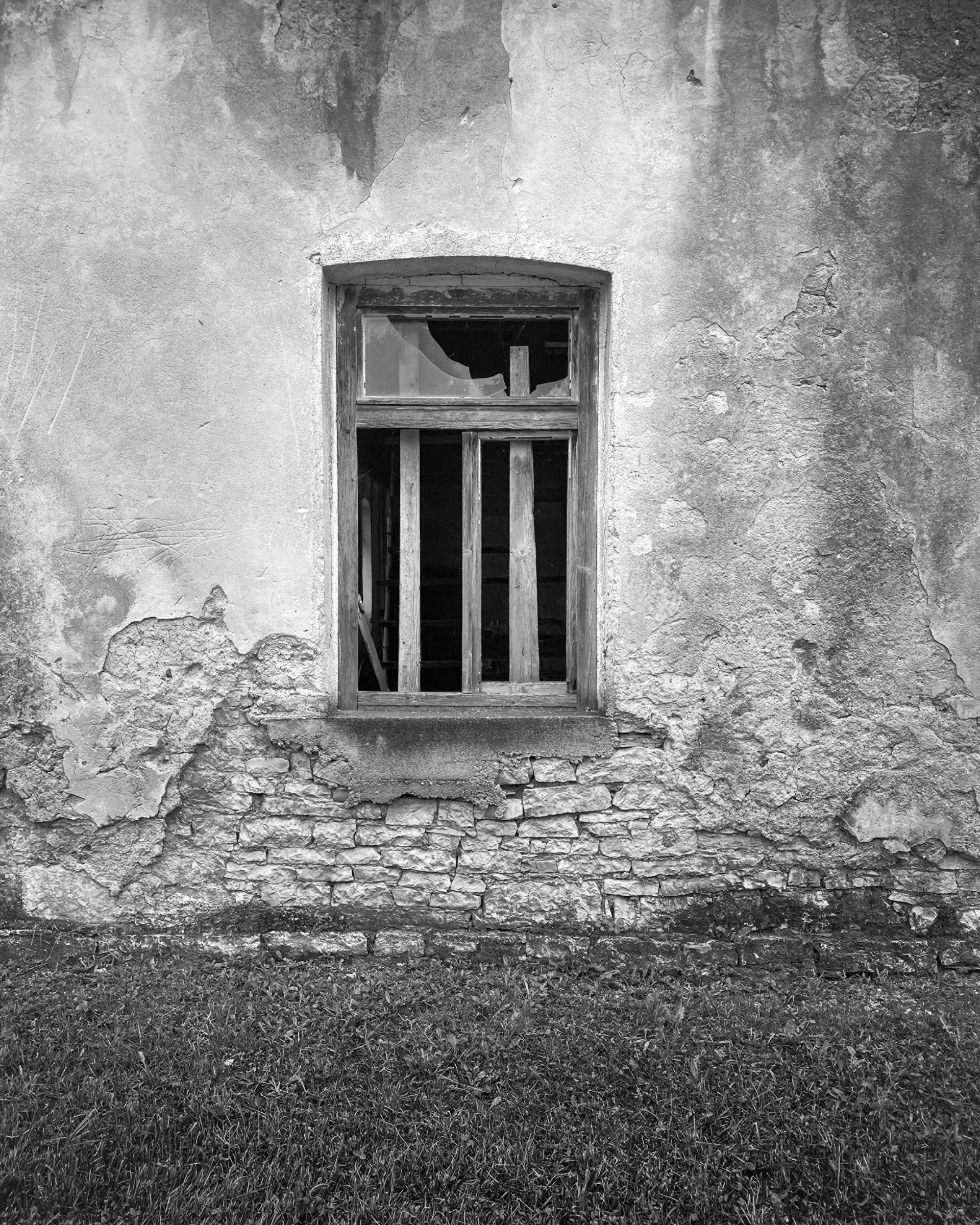
Near Plitvice Lake National Park, Croatia
The area surrounding the famous Plitvice Lakes National Park and its waterfalls is quietly scarred by the Croatian War of Independence (1991-1995). While the tourist-friendly waterfalls remained largely untouched, the surrounding Lika region was an early and sustained frontline. Abandoned houses and farmsteads in nearby villages, often left by displaced populations, still stand with doors hanging open or missing, offering a stark contrast to the natural beauty just kilometers away. The conflict began right here with the Plitvice Lakes incident in March 1991, an early clash that marked the first casualty of the war. The entire region was subsequently held by Serb forces for years and experienced widespread, brutal destruction of small settlements before being retaken by Croatia, leaving a legacy of ruined property and a demographically altered landscape.

Ston Salt Pans, Croatia.
The Ston Salt Pans in Croatia are among the oldest in the world, with a 4,000-year history dating back to prehistoric times when the area was known as "Stagnum" by the Romans. Their golden age began in 1333 when the Republic of Dubrovnik (Ragusa) acquired the territory, establishing a state monopoly that made the salt, nicknamed "white gold," responsible for up to one-third of the Republic's total revenue. To protect this vital economic engine, the Republic constructed the massive Walls of Ston during the 14th and 15th centuries. The traditional, entirely manual harvesting method remains in use today, relying on a complex system of 58 shallow pools where seawater is naturally evaporated by the sun and wind. After one to two months, the brine flows into the nine final crystallization pools—many named after saints—where the pure crystals are formed and scraped by hand using wooden rakes and shovels. The harvested salt is then loaded into small carts, historically pulled by donkeys for transport to stone warehouses. This system reflects the community's values, especially through the Mundo crystallization pool, from which the salt was historically set aside and given to the poor to aid them in food preservation.